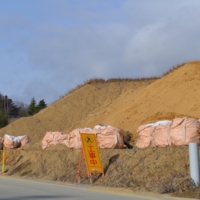
Close Up View of Elevated Land
Title
Close Up View of Elevated Land
Post-Disaster: Japan's Response to the 2011 Earthquake and Tsunami
Subject
natural disasters; disaster planning; construction sites
Description
The elevated land is one way of providing protection from the tsunamis. The streets will remain the same level which will act as drainage zones for possible flooding.
This project was funded by Bernard and Anne Spitzer Travel Fellowship for research projects involving travel abroad and incorporating the study of architecture, landscape architecture, or urbanism.
The purpose of this research trip to Japan is to identify the qualities of successful post-disaster city planning and architecture, which can potentially be applied towards immediate and impervious strategies on a global level. Since the 2011 Tohoku earthquake and tsunami, Japan has undergone massive improvements, due to advancements in construction technology, community-centered and forward-thinking designs as well as a general faith in rebuilding and recovery. Albeit, some of the tsunami-prevention strategies have stirred international controversy, the Japanese are the undoubted frontrunners in ensuring resiliency in saving human lives. Hopefully this information will shed light on some of the ways we as designers can rethink disaster-risk management and recovery.
Creator
Nuguid, Vail
Rights
This image is under copyright. You need to contact copyright owners for any commercial or non-commercial uses. Contact information: digital@ccny.cuny.edu.
Vail Nuguid
Type
Garden and Landscape
Identifier
T0441
Coverage
Rikuzentakata, Iwate, Japan
Files
Citation
Nuguid, Vail, “Close Up View of Elevated Land,” Spitzer School of Architecture, accessed November 18, 2024, http://digitalscholarship.ccny.cuny.edu/architecture/items/show/1119.
Item Relations
This item has no relations.

