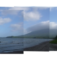
Photo Collage of Playa Santo Domingo, view of the Lake and Volcan Maderas
Title
Photo Collage of Playa Santo Domingo, view of the Lake and Volcan Maderas
Nicaragua Canal
Subject
canals; natural landscapes; construction sites
Description
This project was funded by Bernard and Anne Spitzer Travel Fellowship for research projects involving travel abroad and incorporating the study of architecture, landscape architecture, or urbanism.
In late January 2014, Chinese investment group HKND announced plans to cut a 286 kilometer long and 83 meter wide canal across Nicaragua from the Pacific to the Atlantic. 2014-15 is potentially the last chance to document the Nicaraguan landscape from the Pacific to the Atlantic, along the canal route, before construction begins. There are many questions that I aim to gain perspective on from this trip. 1. What is Nicaragua now, and what might it become? 2. How do the locals feel about the canal? 3. How might tourism be impacted by the canal? 4. What might the viewsheds of the future become for Lake Nicaragua and the Pacific coast?
Creator
Gelband, Lara
Rights
This image is under copyright. You need to contact copyright owners for any commercial or non-commercial uses. Contact information: digital@ccny.cuny.edu.
Lara Gelband
Type
Garden and Landscape
Identifier
T0103
Coverage
Playa Santo Domingo, Ometepe, Nicaragua
Files
Collection
Citation
Gelband, Lara, “Photo Collage of Playa Santo Domingo, view of the Lake and Volcan Maderas,” Spitzer School of Architecture, accessed January 2, 2025, http://digitalscholarship.ccny.cuny.edu/architecture/items/show/684.
Image Viewer
Click below to view an image using the Zoom.it viewer.
Item Relations
This item has no relations.

